


Mallorca Topo Maps
Opis Mallorca Topo Maps
+++ Nowy GPS Mapowanie App +++
Łatwy w użyciu Outdoor / offline app nawigacji GPS z dostępem do najlepszych map topograficznych i zdjęć lotniczych na Majorce.
++ Do użytku offline operacje Pro potrzebne! ++
Włącz Andoid telefon / tablet pod odkrytym GPS do wycieczek w backcountry BEZ CELL pokrycia. Ta aplikacja daje podobne opcje mapowania Jak zapewne wiesz z Garmin lub Magellan GPS handheldów.
Wliczone bezpłatną mapę warstw:
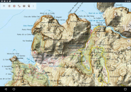
• Mallorca Topo Map: Mapa Topográfico Nacional 1: 50.000 i 1: 25.000 (IGN MTN25 & MTN50)
• Mallorca Mapa bazowa: IGN Baza Topográfica Nacional 1: 25,000 (BTN25 & BCN25)
• Mallorca Imagery: Wysokiej rozdzielczości zdjęcia lotnicze. Plan Nacional de Ortofotografía Aérea (PNOA)
• grunty Rejestracja mapa cartografia Catastral
• OpenStreetMap: Te crowdsourced mapy są bardzo użytecznym dodatkiem do innych warstw mapy. Zawiera wiele unikalnych funkcji.
• OpenCycleMaps: Mapy te są idealne do planowania wycieczek rowerowych
• ESRI topograficzna
• Obrazy ESRI żurawie
• ESRI Plan
• Google Road Map (tylko dostęp online)
• Zdjęcia satelitarne Google (tylko dostęp online)
• Google Mapa terenowa (tylko dostęp online)
• Bing Road Map (tylko dostęp online)
• Obrazy Bing satelitarne (dostęp tylko online)
• Ziemia nocą
• nakładka Hillshading
Główne funkcje Outdoor-nawigacji:
• Tworzenie i edycja waypointów
• GoTo-Waypoint-nawigacja
• Ścieżka zapisu (o prędkości, wysokości i profilu dokładności)
• Tripmaster z pól na liczniku, średniej prędkości, łożyska, elewacji itp
• GPX / KML / KMZ Export
• Szukaj (placenames, POI, ulice)
• Konfigurowalne pola danych w widoku mapy i Tripmaster (np prędkość, odległość, Kompas, ...)
• Waypointy akcję, Tory i trasy (za pośrednictwem poczty elektronicznej, Whatsapp, Dropbox, Facebook, ..)
• Wyświetlanie współrzędnych w Lat / Lon, UTM lub MGRS / usng (Wojskowa Siatka / US National Grid)
• Nagrywanie i udostępnianie utworów ze statystykami i profil wysokości
• Obrót map (Track Up & North Up)
• uzyskać podniesienie długim kliknięciem na mapie
• Ścieżka Powtórka
• i wiele więcej ...
Dostępne funkcje: Pro (Pro funkcje dostępne za pośrednictwem App zakupu)
• w trybie offline - brak pokrycia komórek potrzebne
• Łatwe + Szybka Bulk-pobieranie map płytek do użytku w trybie offline (nie dla Google i Bing Maps)
• Tworzenie i edytowanie tras
• Route-nawigacyjny (Point-to-Point Navigation)
• GPX / KML / KMZ importu
• nieograniczona waypointów i ciężarówki
• Dodaj inny Mapa dachówka Server
• Bez reklam
Offline Zastosowanie:
Wszystkie obiekty kafelki map są przechowywane w pamięci podręcznej. Buforować duże obszary należy zakupić Pro możliwości.
Za pomocą tej aplikacji nawigacji dla zajęć na świeżym powietrzu, takich jak turystyka, kolarstwo, kempingi, wspinaczka, jazda, jazda na nartach, kajakarstwo, polowania, terenowych wycieczek 4WD lub search & rescue (SAR).
Dodaj własne waypointy w długość / szerokość geograficzna, UTM lub formacie MGRS / usng z WGS84 odniesienia.
Import / Export / Share GPS Waypointy / ścieżki / trasy w formacie GPX lub Google Earth KML / KMZ.
Preload DARMOWA dane map dla obszarów bez usługi komórkowej (Pro funkcji!).
Uwagi i wnioski funkcji do mallorcamaps@atlogis.com
Zapraszamy do obejrzenia innych naszych odkrytych aplikacji nawigacyjnych: https://play.google.com/store/search?q=atlogis
+++ Nie śledzimy wszelkie działania użytkowników lub zbierać żadnych danych użytkowników! +++
Mallorca Topo Maps - Wersja 7.7.2
(22-03-2025)Mallorca Topo Maps - Informacje APK
Wersja APK: 7.7.2Pakiet: com.atlogis.mallorcaNajnowsza wersja Mallorca Topo Maps
Inne wersje


 3.64
3.64


Apki w tej samej kategorii


